
Real-Time Location System (RTLS): The Complete Guide
Share this article
Contents
Share this article
What is a Real-Time Location System (RTLS)?
By definition, a Real-Time Location System (RTLS) (Real-Time Location System) is an intelligent network infrastructure designed for the identification, tracking, and dynamic management of assets or people flows.
Unlike GPS, which is designed for open spaces, RTLS is optimized for complex environments: warehouses with steel structures, densely packed factories, or mixed-use industrial sites.
Most RTLS systems are based on a four-component architecture:
Tags: Devices attached to people and/or assets. They support radio protocols (UWB, BLE, etc.) and manage their power consumption using built-in accelerometers so that they transmit only when movement is detected.
Anchors: Fixed reference points that capture signals emitted by tags. The system’s accuracy depends on the ability of these anchors to time-stamp messages to the nanosecond to counter the effects of multipath (reflections off metal).
The Calculation Engine (Location Engine): The algorithmic brain that processes raw data (Time of Flight, TDOA, etc.) to generate X, Y, and Z coordinates.
The Application Platform (Middleware): The interface that transforms raw data into business intelligence: geofencing alerts, productivity dashboards, and digital twins.

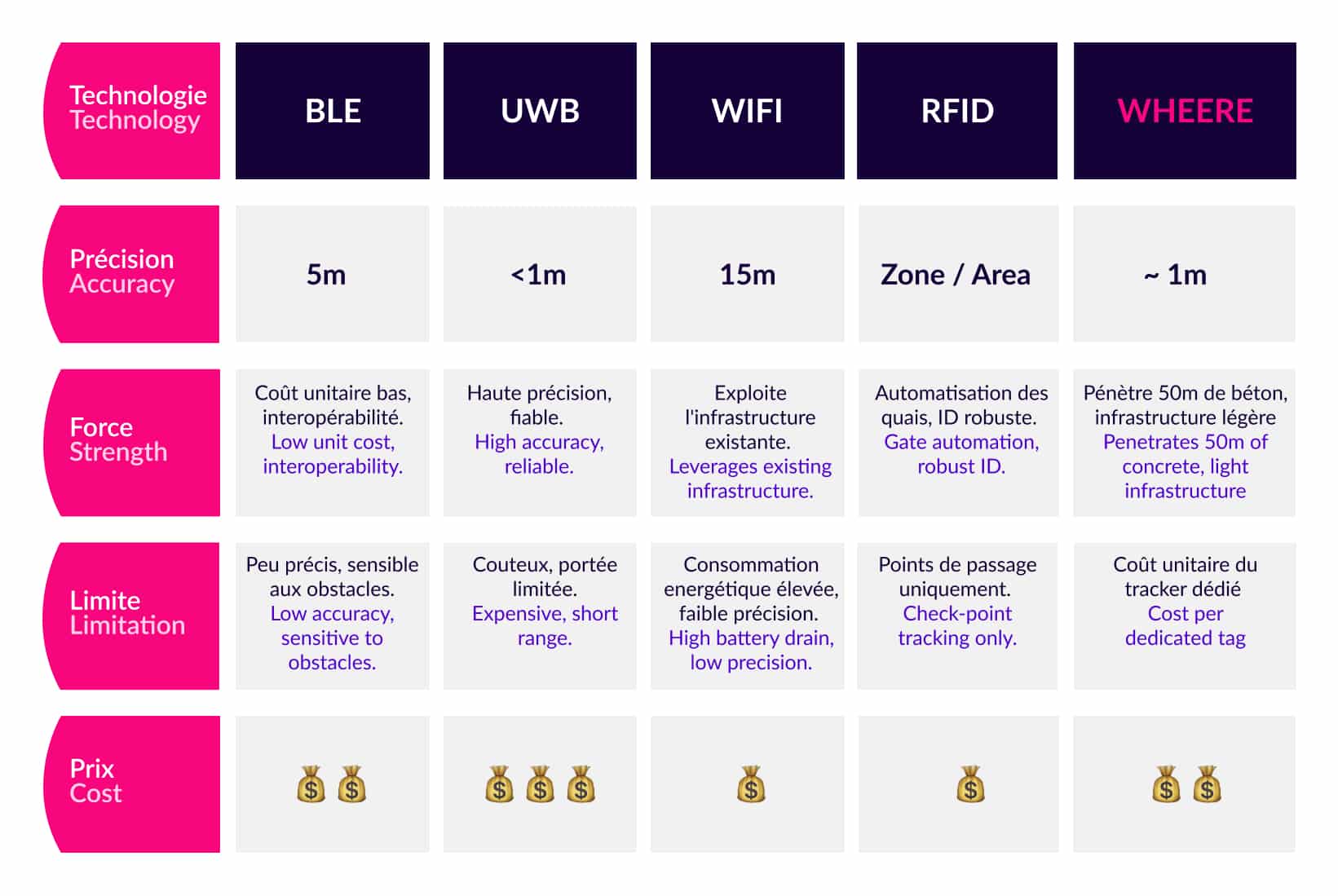
RTLS: Comparison of the 6 leading location technologies
In the rapidly evolving world of manufacturing and logistics, location data has become the new nervous system of smart factories and connected warehouses. Yet behind the acronym RTLS lies a fragmented technological landscape: there is no single solution, but rather a myriad of solutions capable of serving as the foundation for a real-time tracking system.
For technical decision-makers, the equation is complex. Choosing a technology means balancing often conflicting factors: accuracy versus coverage, energy efficiency versus signal latency, or deployment agility versus infrastructure density.
Here is our analysis of thesix main technologies available on the market:
Bluetooth Low Energy (BLE)
Bluetooth Low Energy operates in the 2.4 GHz frequency band. Originally designed for short-range communication between consumer devices, it has established itself as a location tracking tool in the industrial sector thanks to its extremely low power consumption and native interoperability with fleets of mobile devices.
Its main advantage lies in its mature ecosystem and highly competitive unit cost. However, its historical performance, which relies on signal strength (RSSI), makes it structurally sensitive to environmental variations, such as the presence of obstacles or metal reflections. While the introduction of Angle of Arrival (AoA) positioning improves accuracy, BLE remains a solution suited to low-density environments but shows its limitations in large production workshops saturated with radio equipment or metal objects.
Ultra-Wideband (UWB)
Ultra-Wideband uses a wide frequency spectrum to transmit radio pulses lasting one nanosecond. By calculating the time of flight (ToF) of these pulses, the system achieves an accuracy often within 30 centimeters.
This makes it the technology of choice for critical applications, such as vehicle-pedestrian collision avoidance. However, UWB waves do not penetrate physical obstacles well. To maintain accuracy, a beacon must be installed every 20 meters, which increases installation costs and limits this technology to the most strategic areas.
Wi-Fi RTLS
Wi-Fi RTLS uses network access points already deployed in buildings to locate connected assets. It generally relies on trilateration algorithms based on the signal strength detected by nearby access points.
The immediate advantage is reduced initial investment (CAPEX), since part of the infrastructure is already in place. It is a practical solution for tracking IT equipment, scanners, or carts already equipped with Wi-Fi cards. However, accuracy remains low (around 10 meters), and the tags’ energy consumption is significantly higher than that of Bluetooth or UWB. Wi-Fi is therefore ideal for “zone-level” tracking of assets that can be recharged frequently, but is less suitable for granular tracking of people or tools.
Active RFID
Unlike its passive counterpart, Active RFID uses battery-powered tags that autonomously transmit their identifiers to dedicated readers. It is primarily used to confirm the presence of an object within a restricted area around a detection gate.
Its strength lies in its robustness and reliability during rapid passages, making it the perfect tool for automating loading docks or proximity inventories in warehouses. It offers excellent resistance to harsh industrial environments. However, it is not designed to provide a smooth trajectory or perform tracking. It functions more like a series of digital barriers, limiting its usefulness for optimizing picking routes or analyzing production flows.
LoRa (Long Range)
LoRa technology, based on interference-resistant modulation, was designed to transmit small amounts of data over distances of up to several kilometers. For location tracking, it generally uses time difference of arrival (TDOA).
It offers record-breaking battery life and unmatched range. Its major drawback, however, lies in its accuracy—which often ranges between 50 and 100 meters in real-world conditions—and its high latency. It is therefore ideal for determining whether a container is present in a 10-hectare yard, but completely unsuitable for precisely locating a package on a shelf or managing production flows in real time.
Wheere
Wheere has overcome a technological hurdle long considered insurmountable: reconciling indoor coverage with location accuracy. This system relies on the use of unmodulated very high frequency (VHF) radio signals capable of penetrating up to 50 meters of concrete. Only four antennas are needed to cover 1 km² of industrial space.
The antennas broadcast the signals, and the receiver (tracker) calculates its own position. Since there is no return signal from the tag to the anchors, the network never becomes overloaded, allowing for the simultaneous tracking of a virtually unlimited number of objects or people. The system provides three-dimensional (X, Y, Z) metric accuracy with an adjustable refresh rate, ranging from two positions per second to once per day, depending on the requirements of the use case.
What is an RTLS system used for?
For experts in the industrial and logistics sectors, RTLS is not merely a tracking technology, but a tool for optimizing TCO (Total Cost of Ownership) and enhancing process security. Here are a few examples of how an RTLS system can be used:
A. Supply Chain and Warehousing Optimization
- Dynamic Inventory: Elimination of manual inventory counts and automatic real-time reconciliation between physical inventory and the WMS (Warehouse Management System).
- Reduced Search Times: In large logistics parks, RTLS drastically reduces the time spent searching for trailers, pallets, or specific equipment, thereby increasing operator engagement.
B. Production Management (Work-in-Progress - WIP)
- Work-in-Progress Tracking: Automated tracking of production orders (POs). The system identifies bottlenecks and automatically calculates wait times between each production cell.
- Lean Manufacturing (e-Kanban): Replenishment of production lines is triggered by the physical entry or exit of bins into virtual consumption zones, eliminating flow disruptions.
C. Occupational Health and Safety (EHS)
- Lone Worker Protection (LWP): Immediate location tracking in the event of an accident in confined or complex areas where conventional solutions fail.
- Vehicle-Pedestrian Safety: Active management of shared areas, with automatic speed reduction for forklifts when approaching hazardous zones or pedestrians equipped with tags.
D. Maintenance Management (MRO)
- Usage Rate Tracking: Accurate analysis of vehicle operating time to transition from scheduled maintenance to maintenance based on actual usage.
This article may also be of interest to you
5 trends shaping industrial asset tracking in 2026
What are the main benefits of an RTLS system?
A real-time location system (RTLS)offers numerous benefits to industry and logistics professionals.
Here are the four key benefits that transform operational performance:
1. Real-time visibility
By connecting the physical flow to the digital flow, we optimize visibility.
- Instant location: Drastically reduces search times, which can account for up to 20% of operators’ working hours at large sites.
- Continuous inventory: Unlike manual periodic inventories, RTLS enables real-time updates of inventory levels and locations, reducing inventory discrepancies and disruptions in the supply chain.
2. Process Optimization and Lean Manufacturing
RTLS enables the automated collection of data without human intervention (without scanning).
- Identifying bottlenecks: By analyzing dwell times, you can pinpoint exactly where work orders (WOs) are piling up.
- Trajectory Analysis (Spaghetti Charts): Automatic generation of heat maps to optimize picking routes or reconfigure machine layouts in order to minimize travel distances.
3. Enhanced Safety and Risk Management (EHS)
RTLS enables both preventive and corrective measures to be taken to ensure employee safety.
- Geofencing (Virtual Zones): Triggers automatic alerts if an operator enters a danger zone or if a vehicle approaches a pedestrian zone.
- Lone Worker Protection (LWP): In the event of a fall or lack of movement, the system precisely locates the victim, even in complex environments where GPS fails, enabling emergency responders to arrive on the scene within minutes.
4. Profitability and Asset Management
Beyond logistics, RTLS has a direct impact on the company’s bottom line.
- Optimizing TCO (Total Cost of Ownership): By analyzing the actual utilization rate of forklifts or tools, companies often realize that they can reduce the size of their fleet by 10 to 15 percent while maintaining the same production capacity.
- Usage-based maintenance: No more schedule-based maintenance. RTLS enables maintenance to be triggered based on the actual distance traveled by the machine, thereby extending the equipment’s service life.
“The true value of RTLS lies in its ability to eliminate blind spots in the supply chain. Every minute saved on searching, every bottleneck identified, and every route optimized directly impacts profitability.” — Pierre Bolzonello, Sales Director at Wheere.
What are the major challenges encountered when deploying an industrial RTLS?
Installing a real-time location system (RTLS) in a factory or warehouse is an engineering challenge that goes far beyond simply installing sensors. In industrial environments, real-world conditions sometimes contradict the theoretical promises made in the laboratory.
Here are the five major challenges experts face during deployment:
1. The Wave Physics: Reflections and Obstacles
Industrial sites are filled with metal structures (racks, machinery, mezzanines) and concrete walls.
• The multipath effect: Radio signals bounce off metal surfaces, creating echoes that mislead the calculation engine about the tag’s actual position.
• Attenuation: High frequencies (such as 6 GHz UWB or 2.4 GHz Bluetooth) are easily blocked or absorbed by physical obstacles, creating “dead zones.”
2. INFRASTRUCTURE DENSITY
To cover large areas with meter-level accuracy, conventional systems (UWB, BLE) require a very dense network.
• Anchor density: Having to install an antenna every 20 meters is a massive undertaking.
• Cabling and power supply: Each anchor must be powered (often via PoE – Power over Ethernet). In a 20,000 m² factory, the cost of cabling and installation can sometimes exceed the cost of the RTLS hardware itself.
• Maintenance: The more anchors there are, the higher the risk of a network component failure.
3. Radio congestion and interference
Industrial environments are already saturated with wireless signals: Wi-Fi for devices, Bluetooth for connected tools, private 4G/5G networks, and electromagnetic noise generated by motors and welding stations.
• Coexistence: A poorly designed RTLS system can interfere with the factory’s critical Wi-Fi or, conversely, see its performance plummet due to surrounding interference.
4. Software integration and raw data processing
An “X, Y, Z” coordinate has no business value in and of itself. The challenge is to transform these location coordinates into a logistics event that can be understood by an ERP or WMS.
• Interoperability: Connecting the RTLS to existing systems (SAP, Oracle, etc.) requires robust middleware capable of filtering out position “noise” (unwanted position jumps) to report only actual and relevant movements.
5. Tag Lifecycle Management
Deploying thousands of trackers raises critical logistical questions:
• Battery life: A system that requires tags to be recharged too frequently is doomed to operational failure. The expert must balance refresh frequency against battery life.
• Ergonomics and durability: Tags must be shock-resistant, dust-resistant (IP67), and sometimes adapted to the constraints of explosive environments (ATEX standards).
WHEERE: the innovation that simplifies RTLS systems
Faced with these engineering challenges, Wheere offers a disruptive solution that radically simplifies the deployment process.
By utilizing the very high frequency (VHF) band, our technology overcomes traditional physical barriers: where the signal weakens, Wheere penetrates up to 50 meters of concrete, effectively eliminating dead zones without increasing the number of access points.
This breakthrough allows us to move from complex cabling projects to an ultra-lightweight infrastructure capable of covering 1 km² with just 4 antennas.
Finally, by opting for a “broadcast” mode without signal feedback to the anchors, we eliminate the bottleneck of network saturation, enabling the tracking of an unlimited number of assets with consistent reliability.
Wheere makes RTLSscalable, resilient, and accessible to the most demanding industrial environments.
To learn more about Wheere's indoor geolocation technology:
Do you like this article?
Share this and discover other articles you might also find interesting!
- Articles
- News
- Articles