Our company
Wheere, the revolutionary indoor geolocation technology
At Wheere, we've revolutionized indoor geolocation with an innovative, patented approach that goes beyond the limits of traditional systems. We offer unrivalled indoor geolocation technology for precise positioning, both inside and outside buildings.

What is Wheere's positioning technology?
A solution that overcomes the limitations of traditional systems
Traditional geolocation systems, such as GPS or Ultra Wide Band (UWB), rely on the transmission of modulated waves to measure the distance between transmitters and receivers, and thus deduce a position. These approaches require a wide bandwidth, forcing the transmission of high-frequency waves, which do not penetrate walls and are therefore incompatible with indoor use.
Wheere innovation
Indoor geolocation reinvented
Wheere has abandoned traditional binary coding in favor of an innovative method based on two main elements:
The emission of low-frequency waves
Our systems emit low-frequency waves capable of penetrating walls, guaranteeing geolocation coverage inside buildings. Specifically, we transmit on fine sub-bands in the following frequency ranges: 148 -174 MHz.
The Wheere algorithm for sub-metric precision
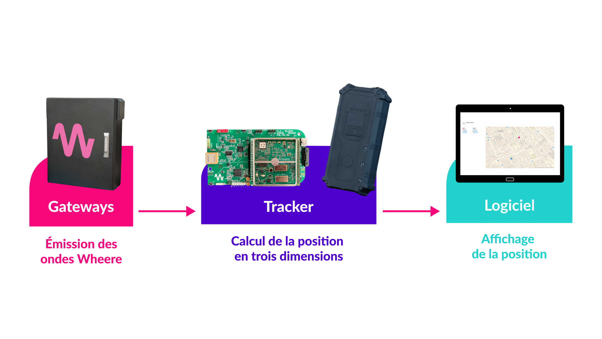
Our solution measures the phase of received signals to deduce the distance between transmitter (Gateway) and receiver (Module). The key point indoors is to separate the direct path from the multiple bounces and diffractions. This is where the effectiveness of the Wheere algorithm lies.


How does our geolocation technology work?
Our current indoor geolocation solution is based on the installation of transmitter stations, known as gateways. Here's how it works:

What are the advantages of Wheere technology?
Our innovative solution offers a unique combination of performance that places it at the forefront of modern indoor localization technologies.
Interior and exterior cladding
Interior and exterior cladding
Scalability
Scalability
Precision and reliability
Precision and reliability
GNSS independence
GNSS independence
Interior and exterior cladding
Thanks to the use of low-frequency waves and our advanced algorithm, we guarantee reliable coverage indoors and outdoors.
Scalability
With just four antennas, we can cover an area of one square kilometer and locate an infinite number of devices.
Precision and reliability
Our system is accurate to less than a metre, and traverses up to 50 metres of concrete.
GNSS independence
In the event of GNSS unavailability (jamming, decoying, etc.), Wheere remains functional.
What are the many applications of our indoor geolocation technology?
Our technology is versatile and finds applications in a wide range of fields: industry, medical, rescue, security and defense.
Here are just a few examples:


What are the different types of geolocation?
There are six main families of geolocation technologies, each adapted to specific contexts and needs:
GNSS
GNSS is based on the use of satellites to provide highly accurate global positioning information. GNSS systems include GPS (USA), GLONASS (Russia), Galileo (Europe) and Beidou (China). Although extremely accurate outdoors, this technology is not effective indoors or in dense urban environments, where signals are blocked or reflected by buildings.
Public networks
Public networks use existing transmitters such as WiFi, 4G/5G and LoRaWAN. The principle is to measure the signal strength received from a known public transmitter and deduce a location zone around it. This method is practical because it uses infrastructure already in place, but it can be less accurate than other technologies due to the variability of signals.
Mesh systems
Mesh systems use a network of interconnected nodes, where each node represents a device capable of receiving and transmitting signals. These nodes communicate with each other to determine the position of an object or tracker. The limitation of this model lies in the dependence of each object in the mesh on the presence of other objects nearby. What's more, geolocation accuracy can be compromised if the location of other reference objects is itself inaccurate.
Local radio technologies
Local radio technologies involve the deployment of anchors such as RFID, Bluetooth and UWB, which act as reference points for a tracker or connected object. These technologies use radio signals to determine position based on signal strength or time of flight between transmitters and receivers. They are effective in indoor environments, but require transmitters to be installed in every room.
Inertial systems
Inertial systems use inertial measurement units ranging from simple three-axis accelerometers to ten-axis IMUs (accelerometers, gyroscopes, barometers and magnetometers). By combining these measurements, they provide displacement information that can be transformed into position by integration or filtering. However, position drifts over time and needs to be recalibrated with other absolute positioning solutions to maintain accuracy.
Optical technologies
Optical geolocation technologies use cameras and optical sensors to determine position based on visual cues. These systems can be highly accurate, and are used in environments where many distinctive visual details are available, such as in warehouses or factories. However, their effectiveness can be reduced in low-light conditions or where there are visual obstructions.
The choice of indoor geolocation technology depends on the specific needs of each entity, particularly in terms of accuracy, cost and existing infrastructure:
- Inertial is the easiest to set up, as it requires very little installation, but its accuracy drifts over time.
- UWB is best suited to high-precision applications, while Bluetooth and Wi-Fi offer more economical and easy-to-deploy solutions.
- GPS remains limited to outdoor environments due to its poor indoor performance.
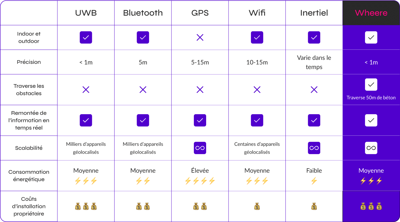
As for Wheere, it's the only technology that can penetrate obstacles and cover an entire site with just four antennas, with an accuracy of less than one meter.
It is essential to carefully assess the requirements of each project in order to select the most suitable technology.
Technology comparison table
UWB
Bluetooth
GPS
Wifi
Inertial

Indoor and outdoor
Precision
< 1m
5m
5 - 15m
10-15m
Varies over time
< 1m
Overcoming obstacles
50m concrete traverse
Real-time information feedback
Scalability
Thousands of devices geotagged
Thousands of devices geotagged
Hundreds of geolocated devices
Energy consumption
Average
⚡️⚡️⚡️
Average
⚡️⚡️
High
⚡️⚡️⚡️⚡️
Average
⚡️⚡️⚡️
Low
⚡️
Average
⚡️⚡️⚡️
Owner installation costs
💰💰💰
💰💰
💰💰
💰
💰
💰💰💰

