
Why doesn't GPS work indoors?
Share this article
Contents
Share this article
From GPS to GNSS, ubiquitous technology
The term "GPS" is commonly used to refer to satellite-based geolocation. However, it refers specifically to the American system. Other constellations include Glonass (Russia), Galileo (Europe) and Beidou (China). Together, these systems form the GNSS (Global Navigation Satellite System).
GNSS has revolutionized our daily lives. In the past, we depended on paper maps for orientation. Today, a simple mobile application is all we need. However, this technology has its limits, especially indoors.
" GNSS has revolutionized our daily lives. In the past, we depended on paper maps for orientation. Today, a simple mobile application is all we need."
Radio waves and their interaction with obstacles
Like visible light, X-rays and microwaves, radio waves are part of the electromagnetic spectrum. They are used in many areas of everyday life: FM radio, television, Wi-Fi, mobile telephony and, of course, satellite geolocation. Their behavior when encountering obstacles depends largely on their frequency, i.e. the number of vibrations the wave makes per second, measured in hertz (Hz).
Frequency and obstacle penetration: a simple physical law
The higher the frequency of a wave, the shorter its wavelength. Yet short-wavelength waves are more easily absorbed, reflected or diffracted when they encounter dense materials such as concrete, metal or even the thick walls of a building. This is true of the waves used by geolocation satellites, which have difficulty penetrating interior structures.
Conversely, low-frequency waves, with their longer wavelengths, are better able to bypass or pass through obstacles. This is why they are used in some military and maritime communications.
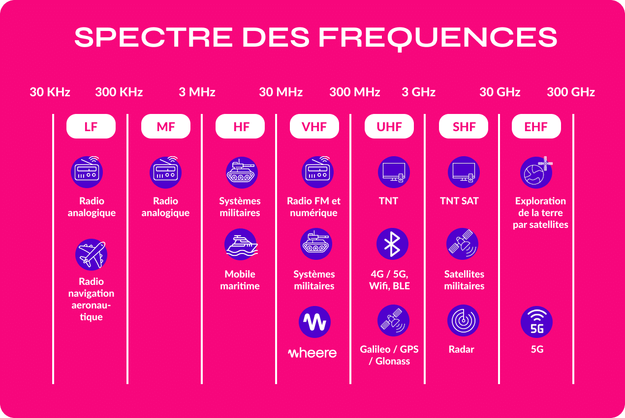
The radio frequency spectrum: a vast and highly regulated area
The radio spectrum extends from around 3 kHz to 300 GHz, and is divided into frequency bands, each with well-defined physical properties and uses:
Long waves (3 - 30 kHz): used for maritime navigation and very long-distance communications.
Medium and short waves (30 kHz - 3 MHz): still used in broadcasting.
VHF (30 - 300 MHz) and UHF (300 MHz - 3 GHz): used by FM radios, TV, cell phones, Wi-Fi and GNSS.
Microwaves (above 3 GHz): used for radar, satellite communications and 5G technologies.
Frequency bands are allocated by national and international authorities (such asANFR in France), to avoid interference and ensure efficient cohabitation between all uses. To find out more, consult the ANFR guide to the frequency spectrum.
The frequencies used by GNSS satellites
GNSS satellites transmit radio signals in the L-band, between 1 and 2 GHz. For example, Galileo satellites transmit on the following frequencies.
L1: 1575.42 MHz
E5a: 1 176.45 MHz
E5b: 1 207.14 MHz
These high frequencies enable fast, accurate data transmission, but are not very effective at crossing solid obstacles, which limits their use indoors.
Why use high frequencies despite their limitations?
It may seem paradoxical to use high-frequency waves, which penetrate obstacles poorly, for a technology as crucial as satellite geolocation. However, this choice is based on physical, technical and regulatory constraints.
A technical necessity: transmitting complex data
GNSS satellites (like GPS, Galileo or Glonass) don't just send out a "beep" that the receiver hears. They transmit modulated signals, i.e. radio waves carrying information in digital form - sequences of 1's and 0's. This information contains :
the satellite's identity,
precise data on its position in space,
and, above all, a very precise timestamp of the moment when the signal was sent.
Modulation is essential to encode and transmit this data. But the more information you want to transmit, the more bandwidth you need (i.e. a larger portion of the radio frequency spectrum). And this bandwidth is much more available and exploitable at high frequencies, particularly in the L-band (between 1 and 2 GHz) used by GNSS systems.
Time-based precision: the importance of the atomic clock
Satellite geolocation is based on a simple but effective idea: measure the time it takes for the signal to travel from the satellite to the receiver. This time is then used to calculate the distance, using the formula:
distance = speed × time
(given that the speed of propagation is that of light in air, i.e. around 300,000 km/s).
For this calculation to be accurate, we need to know the signal's departure time down to the nanosecond. This is why each GNSS satellite is equipped with an atomic clock, which provides an extremely reliable measure of time. By comparing the signals from at least four satellites, the receiver can then determine its exact position in three dimensions using a method called trilateration(→ definition here).
"The use of high frequencies in GNSS systems is the result of a compromise between the need for bandwidth for modulated signals and spectral availability. This technical choice is ideal in the open air, but shows its limits indoors, where waves are blocked or disrupted by obstacles."
Low-frequency geolocation: Wheere's patented solution
To overcome the limitations of indoor GNSS, Wheere has developed an innovative technology:
Use of low frequencies: Wheere emits unmodulated waves in the 148 -174 MHz range, capable of penetrating walls and other obstacles.
Phase measurement algorithm: Rather than modulating signals, Wheere measures the phase of received waves to calculate the distance between transmitter and receiver, enabling precise localization even in the presence of multiple reflections.
This approach enables precise indoor geolocation with metric accuracy, paving the way for numerous applications in complex environments.
Sources and useful links
Did you like it?
Share it and discover other articles you might also like!
- Articles
- News
- News